Showing posts with label future metro map.. Show all posts

Saturday, January 10, 2009

Metro!

First off - MPD Chief Cathy Lainer is bringing back All Hands on Deck at least eight times in 2009, according to the Examiner, here.  I think this is a great initiative, especially with crime on the rise. Keep up the good work Chief Lainer.

WaPo reports that the DHS Project at Saint Elizabeth's has passed another hurdle - getting approval from the NCPC.  I'm all about this.  Read the article here.

Now onto WMATA, I have a few things to discuss ... the first being their budget.

Metro's budget is a mess ... just like transit agencies and governments around the country.  They need to find $176 million in order to operate a balanced budget.  Yesterday, Catoe and his team of fools proposed two cuts - $103 million in operating expenses (operational/admin), and $73 million in service cuts.  They are going to cut about 8% of their workforce - totally 891 positions, which kind of sucks.  But the service cuts are what have me more angry ... I understand the economy is hurting, but that is exactly not the time to propose service cuts - we need more/better service.  The last time the Board voted to increase the Fare (in 2007), they vowed not to do it again until 2010 - who cares.  

While I think the service you get for your $1.35 is lackluster - I propose increasing fares, to a base fare of about $1.50.  I also propose the introduction of Unlimited Monthly passes - available to SmarTrip users only.  Now of course, I haven't done any calculations in regarding these numbers - I think raising the fares is the only option, as I personally don't consider service cuts to be a smart idea.  Cutting service, in any economy is stupid - in a bad economy, it's really stupid.  People need public transportation now more than ever.

Onto the next topic ... which Imagine, DC got me thinking about this morning - another failure (budget cut) during Metro's planning phase ... only two tracks per line.  While putting a second set of tracks (or even just one extra track) on each line would have been extremely costly - I think it would have been better for everyone in the long run.  Imagine DC asks why we can't keep Metro open 24/7 and just single-track around scheduled maintenance - and a commenter responds very smartly, that running the trains just slows everything down to the point where it is basically not worth it.  I really do wish Metro had express tracks ... wouldn't that be lovely.

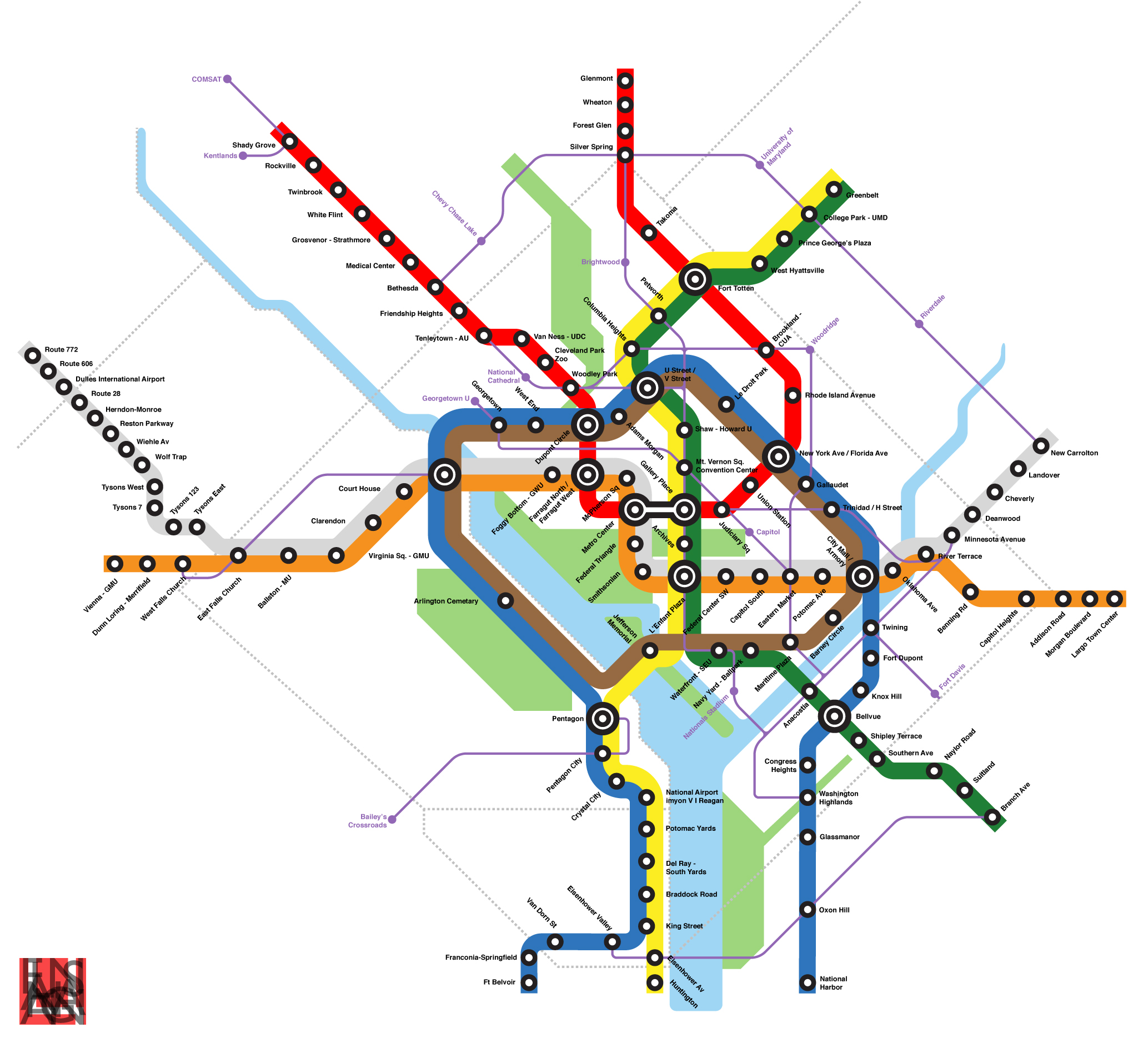
And finally ... TSARchitect came up with a new Metro map (you can view the map here), that is truly amazing.  I don't want to steal his hard work without sending you over to his site for the ad revenue, and for his much more in dept analysis.   My favorite part is that he has added in a 'brown' line - which runs on a circuitous route around the city.  Also the Blue line is not routed along its long proposed M Street run, with TSAR putting it:
this plan does not run the new Blue Line down M street and back into its current configuration. Instead, it runs the Blue Line north, through Adams Morgan, Shaw, Gallaudet, and Trinidad to create a new corridor mostly on Florida Avenue.
I'm not going to steal his thunder ... go read his whole thing.  It really is another great improvement on our ever-lackluster Metro system.

Thursday, January 8, 2009

The return of the streetcar

First off some good transportation news: 
* WaPo is reporting that rail is becoming the preferred way to build the Purple Line ... this is good news especially as this project continues to move forward towards reality - here.
* And ... the best news in a long time, Minister of Transportation Mary Peters has given the final approval for the Dulles Rail Project (aka the Silver Line).  This is great news for Metro, and great news for everyone in Metro Washington.  Now, if only we can get Fairfax County to figure out how to plan Transit-Oriented Development.  The news is here.

So here is the real stuff - I'm going to propose a streetcar plan:

DDOT has posted some historical photos from all around the District, you can view them here - they are pretty cool.  One really struck me, it is a picture from 1958 looking North on Connecticut Avenue NW towards the circle.  Notice the separate tunnels for streetcars underneath the tunnels for cars - I knew that streetcars had run under the circle, but had just assumed they used the car tunnels, and the car just replaced them when the streetcars were discontinued.  The picture is below:

I love the concept of street cars ... they are just a great idea - I would love to see them anywhere.  Since we really don't have them in the US, I like the novelty of them, but I also like them because I think most people consider them more "acceptable" than buses.  I honestly think that is where the streetcars greatest value lies - the fact that people would be willing to take them, yet its not as expensive to construct as a subway.  That said I would gladly accept dedicated bus lanes if the District were not willing to lay out the money for streetcar investment throughout the city.

Yes ... DC is on the road to building a streetcar system, in fact we actually already purchased the streetcars - they are sitting over in Europe somewhere.  And the DC City Council finally approved the streetcar route, along with DDOT ... and everyone is happy - right?  Why haven't you heard about it though?  Well first off, the streetcar is in Anacostia - and while I admit that Anacostia is in desperate need of development and transit-oriented development, I would have liked to see streetcars elsewhere.  In discussing my thoughts on where the first downtown streetcar should go - I would first like to discuss one of the buses I hate the most in the city, the Circulator.

Yup ... I hate the Circ.  I realize that most people don't consider it a bus and because of that people actually use it, and I realize that it serves an area that is starved for mass transit ... but honestly, who runs a bus down K Street.  I think after my second time driving in Washington I developed the rule to avoid K Street at all costs - it is a disaster.  In my mind, this disaster is due to the recent (almost decade old now) redevelopment of the K Street Streescape.  Yes, K Street looks beautiful ... but it is so car-oriented it drives me insane.  The current design is actually pretty much perfect to just put streetcars down onto.  I have made two excellent images in paint showing the current traffic pattern, and then what I would like to see.


My proposal gives the streetcar an isolated dedicated lane (perhaps it could even be shared by bus routes that might be using K Street), as well as a dedicated station (loading/unloading) platform ... much like the median that already exists on K Street.  I would personally prefer that we just eliminate street-parking along K Street, as I think the the third travel lane would be better used as just that - a true lane 24/7; I know that just won't give with the businesses and the ANC - they love parking.  So they have their parking ... during off-peak hours, much like it is in other areas of the city.

I would personally like to see most left turns banned on K Street as well - unless the parking lane is eliminated and the left-turners are given a dedicated turn lane and arrow.

This K Street streetcar network would travel under Washington Circle - with a station under the Circle, much like old DuPont - but it would alter course slightly and when it came back up to ground level it would be on Pennsylvania Avenue.  The streetcars would travel down dedicated lanes on Pennsylvania ... until it reached Georgetown.  Exactly what happens in Georgetown will be covered in a separate, soon-to-come, post.

But I would like to turn your focus back in the other direction ... when the K Street streetcar comes to Connecticut I forsee a large link-up.  Since the Metro is below ground, and the NPS is not going to let me raze Farragut Square, there will unfortunately not be one easy transfer route - but in theory I'd like all the trains to be able to move from track to track ... but if not here is what I envision.  The K Street streetcar continues on down K street, eventually hitting Convention Center area ... at that point it will head down Mass Ave towards Union Station - where it will terminate and meet up with several other lines, much like the Circulator.

Additionally at Connecticut Avenue - there will be a pair of tracks that head Northbound on Connecticut - and a pair that continue from those Connecticut tracks heading Southbound on 17th Street down to the WWII memorial.  I'd love to really sit down and plan all of this, and perhaps I will in a future post.

Additionally the downtown core isn't in desperate need for transit, there is a sufficient amount of transit, just nothing really that good.  Anacostia needs transit, H Street NE/Bloomingdale needs transit, upper NW really needs transit (as does upper NE). 

Of course that could all change if one day metro was to look like this.  Original post here.

Look for more of these posts to come.